The council depot on the north side of Mill Road, west of the railway line is due to be redeveloped for housing. The developer will be Cambridge Investment Partnership (CIP), a joint venture between Cambridge City Council and Hill, a commercial housebuilder.
Response to planning application
South Petersfield Residents Association objects to this planning application on the grounds outlined here, and urges the planning committee to refuse consent.
Local Plan (LP) references are to the draft Local Plan (2013).
Open space
There is great need for more open green space in Petersfield, but this development will deliver less than the draft Local Plan requirement. The application site area is given as 2.14ha and the required open space as 0.77ha (LP Policy 68), yet only 0.6ha is being provided. Much of that is the Chisholm Trail, which is in fact a tarmacked cycle/footway with just a 1m deep grass verge. This does not fit the description of ‘informal open space’, defined in the Local Plan as “recreation grounds, parks and natural greenspaces.”
The proposed provision of open green space is too fragmented for recreational use. With the exception of the playground for young children, the green space provides breathing space for residents, but nothing that could be used by older children (‘youth space’), to play informal sport or games; nor is it large enough for community events.
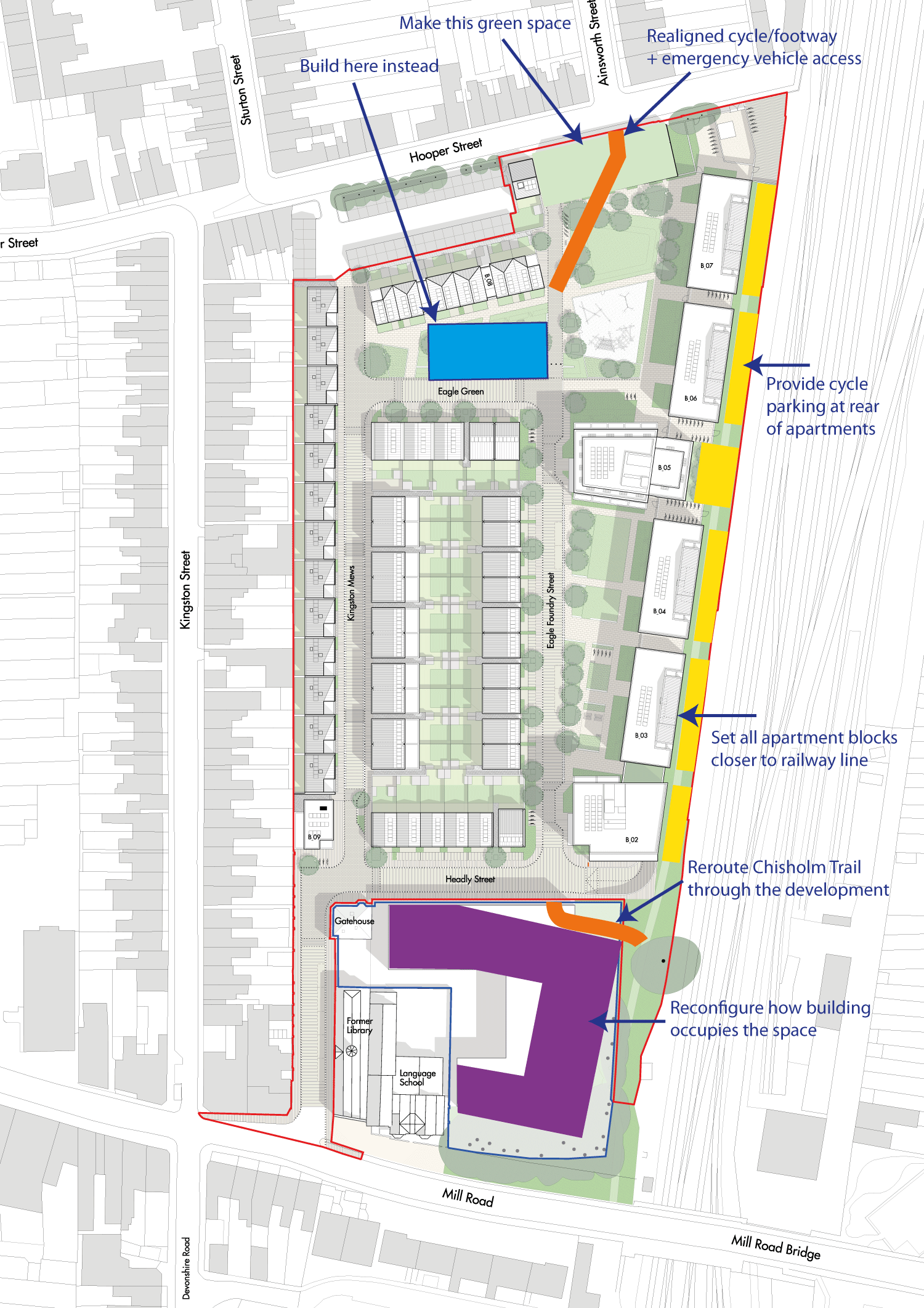
We also have a serious concern about the indicative footprint and orientation of the future building by Mill Rd. It leaves ‘dead space’ next to the Mill Rd bridge and railway line, which has been assessed as dark, noisy and polluted. There is a real concern that this area and the railway arch could be attractive for those who live on the street, many of whom have drug and alcohol dependencies and mental health problems. This would be intimidating to those using the Chisholm Trail, especially after dusk.
Applicable Local Plan policies
68 (7.49) New major developments will need to meet their obligations on open space on-site, as opposed to relying on spare capacity within existing facilities.
Recommendations
We would like to see a revised plan in which:
1) There is at least the minimum of ‘informal open space’ as defined in the Local Plan.
2) There is a larger, contiguous open space at the northern end, opening onto Hooper St, opposite the junction with Ainsworth St (see Figure 1 below). This could be achieved by removing the five terraced houses that front onto Hooper St, and instead building residences on part of Eagle Park. This would realise two key benefits:
- It would open up a vista from Hooper St onto the public open space, making it more accessible and inviting to residents of neighbouring streets, and more suitable for community events.
- It would make it possible to align the main cycle/foot access to the site with Ainsworth St, improving safety at this awkward junction, and improving legibility of the route through the site.
3) The Chisholm Trail is re-routed (see below), allowing the apartment buildings to be set slightly closer to the railway line, increasing green space in the main body of the site.
4) Space behind the apartments is used for secure cycle parking. (There would be no through route behind the apartments.)
5) The ‘future building’ is oriented parallel to the railway line, substantially increasing the area of the courtyard. This may require the removal of two or three trees that currently stand between the car park and the railway line, but this shouldn’t rule this out as an option. (Of course replacement trees should be planted elsewhere on the site.)
Parking provision
Overprovision for residents
We believe that 151 spaces for 184 dwellings (a ratio of 0.82) is far too high when the SPD states that “the aspiration is to provide low car parking provision.” We interpret that to mean, lower than is typically found in this part of Cambridge. Camcycle did an informal audit of local streets on 13 November, and concluded that the ratio of parking spaces to houses is close to 0.5. We have suggested to CIP that they obtain figures from the County Council for the ratio of vehicle permits to households in the Petersfield parking zone to confirm this.
The published ratio of 0.65 omits visitor spaces, but we see no reason to make this distinction, as it’s not made for on-street parking elsewhere in the ward.
There is little justification for providing a higher ratio of parking spaces for an inner city development, within easy walking and cycling distance of all amenities, from supermarkets to the railway station. It’s a waste of valuable space.
In order to make car sharing more attractive and convenient, there should be more than one parking space assigned for shared cars.
Car storage for the wider community
There is however an opportunity to remove a significant number of vehicles from surrounding streets by offering underground spaces in this development for rent to non-residents. This may argue for creating the largest basement car park that it’s cost-efficient to build, budgeting a long-term future income to the freehold management company.
Reducing car parking pressure on surrounding streets would enable space to be reallocated, for instance to provide:
- More on-street cycle parking
- Longer double yellow lines around junctions to improve safety
- Elimination of pavement parking (e.g. on the east side of Kingston St)
- Communal bin storage areas (perhaps underground as in Eddington)
- Trees and plant beds
In order to drive this change, the City and County Councils should agree a phased reduction in on-street parking provision. One way could be to set a target percentage reduction in parking provision in an electoral division (perhaps starting at 1% and increasing annually). The County Councillor would be responsible for agreeing with residents which bays are to be removed and what they are to be replaced with. Implementing a residents parking zone might exempt an area from reducing provision for a few as an added incentive.
Loading/unloading
It is unclear what the status is of the four parking bays marked on Eagle Foundry Street. These obstruct a route that will be well used by cyclists (whether or not the Chisholm Trail is rerouted as proposed below).
There is a need for loading (short-stay) bays throughout the site for delivery vehicles, and residents without on-plot parking.
Applicable Local Plan policies
81 (9.22) In areas of the city where traffic congestion and/or pollution from traffic are particularly high, a zero increase or reduction in car traffic through any proposed redevelopment will be sought. This includes the City Centre and Newmarket Road.
82 Car-free and car-capped development is acceptable in the following circumstances:
- where there is good, easily walkable and cyclable access to a district centre or the City
Centre; - where there is high public transport accessibility; and
- where the car-free status of the development can realistically be enforced by planning obligations and/or on-street parking controls.
Recommendations
6) Replace on-carriageway parking bays with offset loading bays space evenly throughout the site.
7) Rather than impose a garage on prospective owners of the detached houses, provide more living space on the plot and offer the option to lease a parking space in the basement under the apartments.
8) Provide surface parking spaces off the carriageway for two, not one, rental cars (both with charging points).
9) Ensure that there are short-stay parking bays throughout the development to facilitate loading/unloading and deliveries.
10) If it is cost-effective to build a large basement car park, then make excess spaces (above a minimum allocation required for residents of this development) available to rent as car storage for residents outside the development.
Chisholm Trail
The junction of Ainsworth St and Hooper St has poor visibility, as the building edges are close to the road and the pavements are narrow. For safety and legibility of the route for people walking and cycling, we would rather the route aligned with Ainsworth St (see ‘Open space’ above).
Safety
We have grave concerns about how safe the Chisholm Trail will feel. Part of feeling safe is knowing that there are escape routes and help close at hand (such as a door to knock on) if needed. The proposed design has the Chisholm Trail hemmed in for over 150m between a wall with locked gates and a fence. The route will not be well surveilled, as there are no ground floor windows overlooking.
If someone were to be mugged on this section of the Chisholm Trail, it would become a virtual no-go area.
Applicable LP Policies
56 (d): Proposals should ensure that buildings are orientated to provide natural surveillance.
56 (g): Proposals should be designed to remove the threat or perceived threat of crime and improve community safety.
Recommendations
11) Re-route the Chisholm Trail via Eagle Foundry Street.
12) Re-align Eagle Foundry Street to connect with Hooper St opposite Ainsworth St.
13) Create a wide segregated cycle/footway link from the path south to Mill Rd bridge to Headly St, joining opposite Eagle Foundry St.
Junction with Mill Rd
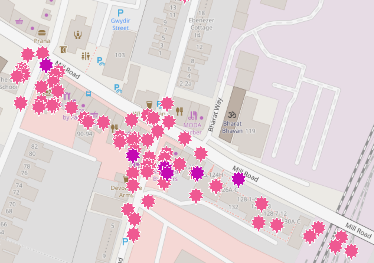
The Depot junction and Devonshire Rd-Kingston St junctions have a poor safety record (see Figure 2). This development is expected to generate 1,246 trips per day. Most of these will be on foot and by cycle via Mill Rd, adding considerably to the volume of people using the narrow pavements and trying to cross the road.
The Chisholm Trail will provide an alternative to crossing Mill Rd to reach the station and beyond. Direct access to it from Mill Rd would benefit in particular residents of Kingston St and Great Eastern St, who do not have access to a pedestrian crossing on the most direct route to the station.
This would be achieved by opening a connection to the Chisholm Trail via the access road alongside Mill Rd bridge (in front of Regent Cambridge language school). This would also increase the permeability and safety of the Chisholm Trail at a point where there is a risk of antisocial behaviour or worse (see Chisholm Trail above).
It is our understanding that County Council Highways officers have objected to opening up this access on the grounds that people cycling would meet Mill Rd at a dangerous angle. If this is true, it can surely be addressed by careful junction design.
Additionally, there needs to be either a zebra crossing of Mill Rd between Kingston St and Bharat Way, or traffic lights at the Devonshire Rd-Kingston St junction. Consideration needs to be given to the fact that HGVs have to cross the centre line in order to turn left into Devonshire Rd.
Applicable LP Policies
81 (9.24): Financial contributions will be sought towards schemes approved by the City and County Councils for any necessary improvements required as a result of development. The existing conditions on the wider transport network and any increase in demand over and above the existing use’s levels will need to be taken into account.
Recommendations
Require, as part of the S106 agreement, that funds are provided to:
14) Connect the Chisholm Trail to the access road alongside the north side of Mill Rd bridge, and redesign the junction at Mill Rd to increase safety.
15) Improve the safety of this section of Mill Rd with traffic lights and/or a new pedestrian crossing.
Future building next to Mill Rd
The S106 commitment on community space for this development is to be delivered as part of a future planning application. This is not acceptable as the community has a right to know what that provision will be.
Recommendations
16) Refuse or defer this application until it can be considered alongside the application for the ‘future building’ containing the S106 community space.
Cycle parking
We are pleased to see a strong commitment to providing cycle parking, including for off-gauge (cargo/trailer) bikes. However the provision of surface cycle parking in between the apartments has severely reduced the permeability of the Chisholm Trail. The recommendations here will make cycle parking more accessible and release basement space.
Recommendations
17) Reroute the Chisholm Trail through the development (see above).
18) Relocate all secure cycle parking to behind the apartments rather than in the basement and in between apartment blocks.
19) Retain visitor cycle parking racks between the apartment blocks.
EV charging
The proposal is to have 50% of the underground parking spaces with active or passive (unconnected) charging points. It is generally accepted that almost all new cars will be electric within a decade.
Recommendations
20) Provide at least passive provision for a charging point for all parking bays.
Response to second consultation by CIP (for reference)
Parking provision
We would further suggest that, rather than impose a garage on prospective owners of the detached houses, provide more living space on the plot and offer the option to lease a parking space in the basement under the apartments. The street in front of the houses will need short-stay waiting bays in any case (for deliveries and tradespeople), so owners will still have the convenience of being able to load/unload their car in front of their house.
Cycle parking
We are pleased to see a strong commitment to providing cycle parking, including for off-gauge (cargo/trailer) bikes. However, provision is still too low to meet the aspiration for a low-car development. A significant proportion of 1-bed apartments will have too occupants plus occasional visitors, so 1 cycle parking space per apartment will not be sufficient. A case can be made for having closer to 400 spaces (not including the YMCA). We would like to see more detail on the provision for the apartments, especially for off-gauge bikes (cargo/trailer), which are becoming increasingly popular, and make car-free living possible for many more people.
Providing too little cycle parking will lead to bikes being scattered around the site, as has happened on so many other developments (e.g. around CB1).
EV charging
Open space
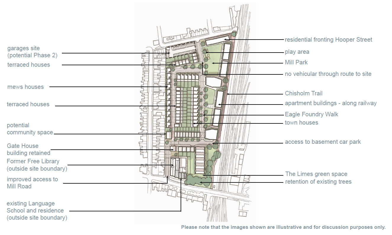
YMCA building
Chisholm Trail
Leased garages
Cambridge Womens Resources Centre
Response to initial consultation by CIP
Inadequate ambition on car usage
Average car ownership in Petersfield and Romsey is much lower than is being proposed in the depot site plans. The apartments recently built around Great Northern Rd in CB1 have 48 parking spaces for 137 units, a ratio of 35%. CIP are proposing about 210 spaces for about 230 units, a ratio of 91%.
We would like to see a large reduction in allocation for surface parking in order to create more public space, a more attractive environment, and more affordable houses. The only surface provision should be for loading, tradespeople, shared cars (e.g. Zipcar) and disabled parking.
Parking (or, more accurately for most people, car storage) provision for the entire site could be contained in the basement of the apartment block. Houses could be provided with more living space and a covered, secure storage space for bikes, gardening equipment, workshop, or whatever – considerably smaller than the proposed garages.
Need for affordability
We want to see a clear commitment to substantially more than 40% affordable housing, and for ‘affordable’ to mean genuinely affordable to ordinary people, with a mix of rented and different ownership structures.
We are concerned that the partnership with Hill means that there will be too much emphasis on generating profit, rather than satisfying the social need for affordable housing. We understand that Hill brings valuable expertise, but it is not clear who is driving this project and for whose benefit. This needs to be articulated clearly with no moving of goalposts later on. This is a unique opportunity to provide for many current and future generations of Cambridge residents. It must not be squandered or compromised.
Public space
Petersfield is short of attractive, usable public space. The most recent additions, Ravensworth Gardens and St Matthew’s Gardens are both disconnected from the wider communities, and therefore underused. For public spaces to be well-used and loved, they must be visible, adjacent to and readily accessible from a major public thoroughfare.
The local community would like to see more than the minimum amount of open space required on this site. A number of recent developments in the area have avoided their Section 106 obligation to provide public space by making a payment to the council instead. As there is no other land available to develop for open space, it has been spent instead on “improvements”. We need more green space!
The best locations for open space on the site are on the south-east corner, which is visible, adjacent to and accessible from Mill Rd; and the north side adjacent to Hooper St.
The initial plan differs greatly from the SPD in having large houses built in the south-east corner. This is not the most desirable location to have a house, being overlooked from the bridge, shaded by trees, and exposed to the greatest road noise. Better to have an open space large enough for people to kick a ball around without causing a nuisance to neighbours. The space would also be ideal for community events, e.g. as part of Mill Rd fairs.
The northern space, incorporating a children’s play area, would be well used by residents of St Matthew’s, being far from traffic noise and pollution.
Some open space should of course be included within the site too, but larger spaces will see more use than many disconnected small pieces.
Design
This site must aspire to be award-winning, and a reference for future developments. We want to to see high quality architecture that is crafted, sympathetic to the local area, and interestingly innovative. The urban design, architecture and landscaping should promote a happy and engaged community. The development should demonstrate best practices in sustainable design, for energy and water consumption, drainage, waste disposal, etc.
Car parks off Hooper St
The cost of waiting for Hooper St garage leases to expire, then redeveloping the site at a later date must be considerably greater than doing it when access and machinery is available from the main site. There is also a large opportunity cost in not providing the ten or so new houses that could be built on the site.
The garages are an ugly waste of valuable space. They no longer serve the purpose for which they were originally intended (to remove cars from Ainsworth and other local streets) as they are let to people well outside the immediate locality and most likely used for general storage.
We understand that at least some current leaseholders have already been approached and rejected whatever offer was made to them. This is too important an issue to leave there. A full cost-benefit analysis must be carried out (with an upper cost limit based on valuations for compulsory purchase – which would not of course be made public). More creative thought should be put into developing options to offer current leaseholders like-for-like or better alternatives.
Hooper St access road
The blocked-off access from Hooper St appears to take up valuable space for little purpose. There is no obvious benefit for refuse trucks, which will need to make a circuit of the site, not go through it.
It would be a more efficient use of space to provide a single pedestrian/cycle access point to the site (which could be wide enough for an emergency vehicle) opposite Ainsworth St. The cycle lane would split off towards the railway line and the footway would continue straight on through the development (and be landscaped so as to be less attractive as a cycling route).
Workshops
The workshops organised to develop the SPD were well-attended and positive. Much was lost in translation in the SPD, and there is a growing feeling that the SPD, and now the initial concepts, are departing significantly from the vision that the community was developing. I would urge CIP to run another workshop or two before committing to detailed designs. Exhibitions have their place, but they are not the most effective way to gather ideas. Well-run workshops promote dialogue, understanding and trust. That’s what we all need!
Supplementary Planning Document
The City Council drew up a Supplementary Planning Document (SPD) that sets out a framework for how the site will be developed.
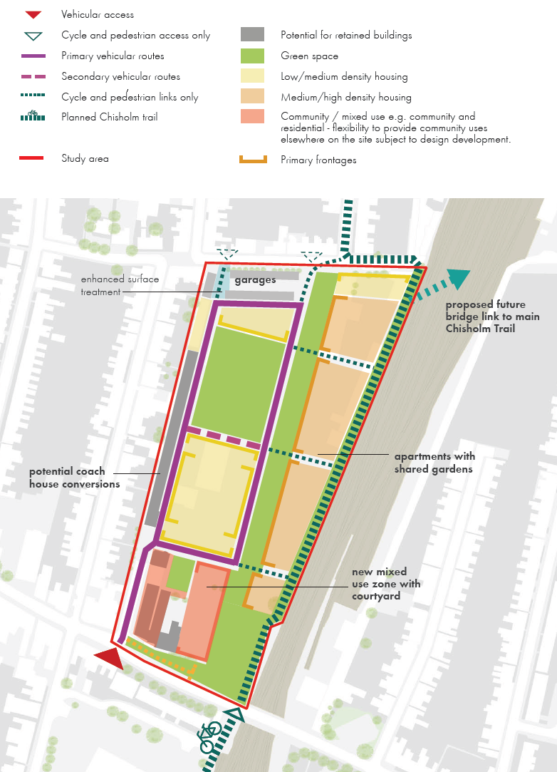
There is much to be commended about the SPD, but it seems that few of the issues raised in earlier consultations have been taken aboard (e.g. with regards to joining up the green spaces, being zero car, removing or relocating the garages (e.g. underground), sustainability (e.g. energy production and water conservation), and integrating the Chisholm Trail cycle route).
There is a desperate need in Petersfield for accessible, usable green space. The SPD reserves quite a lot of land for green space, but it’s not as accessible to the wider community as it needs to be (think of the underused Ravensworth Gardens pocket park). If more of the open space at the depot were joined up, visible and easily accessed from Mill Road, it would see more use – day-to-day and for community events.
The SPD was approved by the Development Plan Scrutiny Sub-Committee on Wednesday, 22nd March, 2017.